Our website uses cookies. They help us understand how customers use our website so we can give you the best experience possible. By continuing to browse this site or choosing to close this message, you give consent for cookies to be used. The cookies are not used for advertising. This applies to visitors from EU.
Differential Global Positioning System (DGPS)
DGPS / GNSS Systems
Differential Global Positioning System (DGPS)
Product Details;
An enhancement to Global Positioning System providing an improved location accuracy, from the 15m nominal GPS accuracy to about 10cm, at best.
DGPS uses an amalgamation of receivers and satellites that –
  • Significantly improve the rate of accuracy from 100s of metres, to centimetres, to millimetres
  • DGPS leverages network fixed ground based reference stations in familiar locations.
  • The base station draws a comparison between its own location, to the one computed from the GPS receiver.
  • The difference is then broadcasted as a correction to the user. The correction signals can either be broadcasted via the ground stations, or from the additional satellites. These privately owned services usually require a user subscription.
  • The Differential GPS can replace an entire month of manual work with traditional methods. The labour saving is substantial, however, at the same time, tasks that were previously rendered impossible like predicting earthquakes before they occur, have now been made possible.

 GNSS Systems
GPS/GNSS system studies the use of GPS and GNSS signals, using a GPS/GNSS system/ receiver and antenna to decide the boundary, form, position of objects and points in space relative to other boundaries, forms, and points. This ousts the traditional opticals and mechanical processes of surveying that rely solely on the theodolites and distance measuring equipment that leverage linear and angular measurements, and the application of trigonometry and geometry.

Geode Real Time Sub Meter GPS Receiver
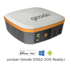
Geode, Real Time Submeter GPS – Gagan Enabled – Specially to use in Mapping and General Survey Applications.

Product Details
Juniper Systems, Geode
Looking for a simple sub-meter GNSS solution at an affordable price? With the Geode, you can easily collect real-time, sub-meter GNSS data without the huge price tag or complexity of other precision receivers.
Designed with versatility in mind, the Geode works with iPhone and iPad as well as a wide range of Windows®, Windows Mobile, and Android™ devices and is especially useful for bring-your-own-device workplaces.
Take the Geode with you mounted on a pole, in a pack, or held in your hand to collect real-time sub-meter GNSS data in harsh environments, using almost any handheld device.

Features

SUBMETER ACCURACY
Use the Geode with a handheld device to easily collect sub-meter GNSS data
REAL-TIME DATA
The Geode uses multiple correction sources to provide precise, real-time data
AFFORDABLE
Get the professional accuracy you need at a budget-friendly price
ALL-IN-ONE
Inside, the Geode contains both receiver and antenna, providing an all-in-one GNSS solution
COMPACT SIZE
The Geode is small and lightweight — easy to pack around for all-day use
OPEN INTERFACE
Use the Geode with any of Juniper Systems’ handhelds or your own iPhone, iPad, Windows, or Android device
ALL-DAY BATTERY LIFE
Overtime Technology battery is ideal for long workdays and conserves power in extreme temperatures
JUNIPER RUGGED
Designed to withstand harsh environments for consistently reliable performance
SIMPLE TO USE
Intuitive and easy operation — one-button simplicity
SL900 GNSS Receiver solutionThe SatLab GNSS receiver is a high-precision that performs even under the most demanding conditions. With this GNSS Receiver. it is capable of delivering highly accurate gps data in real-time to any devices via a Bluetooth connection. Satellite correction service,compact and lightweight, this RTK GNSS is one of the most flexible solutions that promises positioning reliability.
Tilt compensation solutionWith surveyors in mind, SatLab GNSS designed a solution to increase efficiency in your workflow by cutting down time wasted from offsetting slanted measurements. With the tilt compensator and GNSS antenna, the GNSS Receiver can save up to 20 percent of time compared to conventional surveying practices. This GNSS solution allows you to focus on your surroundings conveniently while ensuring your safety and comfort.
Efficient and dependablePowered by NovAtel OEM729 GNSS engine, this receiver offers precise positioning and advanced interference mitigation which performs even in the most remote or challenging environments. Using its 555 channel tracking capabilities, it can track all current and upcoming signals, offering sub-metre excellently to centimetre precise positioning with different modes (RTK, PPK, Static).
Satellite correction service
The GNSS Receiver has TerraStar capabilities that use a global network of multi-GNSS reference stations and advanced algorithms to generate highly precise GNSS satellite orbit, clock, biases, and other system parameters. These data allow TerraStar to provide correction services with sub-metre or centimetre-level positioning accuracy to receivers. Get your corrections transmitted in real-time, with minimal latency via satellites and cellular networks wor
ldwide.
Positioning
GPS:
L1C/A, L2E, L2C, L5
GLONASS:
L1C/A, L1P, L2C/A, L3 CDMA
Galileo:
E1, E5A, E5B, E5AltBOC, E6
BeiDou:
B1, B2, B3
SBAS:
L1C/A, L5 QZSS, WAAS, MSAS, GAGAN, EGNOS
IRNSS:
L5
QZSS:
L1 C/A, L2C, L5
L-Band:
OmniSTAR, Trimble RTX (optional)
Channels:
336
Performance
Real-time Kinematic:
H: 8 mm + 1 ppm RMS / V: 15 mm + 1 ppm RMS
Network RTK:
H: 8 mm + 0.5 ppm RMS / V: 15 mm + 0.5 ppm RMS
Post Processing Kinematic:
H: 8 mm + 1 ppm RMS / V: 15 mm + 1 ppm RMS
High-precision Static:
H: 2.5 mm + 0.1 ppm RMS / V: 3.5 mm + 0.4 ppm RMS
Static and Fast Static:
H: 2.5 mm + 0.5 ppm RMS / V: 5 mm + 0.5 ppm RMS
DGPS Position Accuracy:
H: 25 cm RMS / V: 50 cm RMS
SBAS Position Accuracy:
H: 50 cm RMS / V: 85 cm RMS
Code Differential:
DGPS/RTCM
Initializing Time:
2-10 s
Initializing Reliability:
99.9%
Tilt Compensation:4 cm accuracy in the inclination of 30°
Physical
Size:170 mm x 95 mm
Weight:1.2 kg (including battery)
Battery:5,000mAh Lithium-Ion Battery
Battery Life:10 hours (RTK Rover)
Environmental
Environmental Protection:IP67
Water:Waterproof to 1 m (3.28 ft) depth
Shock/Vibration:MIL-STD-810G, 514.6
2 m (6.5 ft) pole drop
Operating Temperature:-40 °C to +65 °C
Storage Temperature:-40 °C to +85 °C

Write a review

Note: HTML is not translated!
    Bad           Good

Differential Global Positioning System (DGPS)

  • ₹0

Seller information

  • Paragon Instrumentation Engineer

  • Paragon Instrumentation Engineers Pvt. Ltd.
  • Roorkee, India
  • Business Type :Supplier, Manufacturer
View profile
Please sign in to contact Paragon Instrumentation Engineer

Tags: Construction